
Two-sides of map
The map limits the geospatial community, but the consumer mapping sector needs an adrenalin shot.

In an age where clear one-sided thinking and binary-ism (red vs blue, left vs right, etc.) are praised, I want a nuanced discussion both for and against the humble map. As strategists, we need to be able to parse complexity and hold opposing ideas in our minds. I am deeply agnostic in my views on technology, but some will take this as criticism. It’s not; I am impressed by anyone who enters the arena and in awe of those who meet with success. The companies I reference in this discussion have done both of those things.

The territory is not (just) the map
The map is a problem for geospatial. Whilst being the most powerful, useful, and often beautiful visualization tool for geographic information. The map is also a barrier for those who are unfamiliar or untrained in cartographic representation.
Esri, a company we can all agree dominates the mapping world, has been selling its technology for probably five decades—an amazing company. But one cannot buy their technology in parts; one has to buy the whole stack, and at the center of that stack is, most recently, ArcPro—the map. I will caveat this discussion with the observation that licensing deals change, and maybe this practice, in particular, has changed. Still, it has certainly been the case for decades that one could not buy parts or single algorithms from Esri. For instance, I couldn’t buy a billion geocodes for a tech company from Esri, a decade ago. Not without buying “everything else too.” So, the map has always been baked in.
This has meant that one could not abstract geographic activities from their subsequent presentation on the map. More so, the Esri sales and marketing teams would reasonably avoid or ignore any opportunity that didn’t touch a map in some way because there would be no meaningful business opportunity. The net result of this is that any non-map-based geospatial activities were done elsewhere or just not done. Over time, I would argue, this has limited the reach of geospatial practices. Beyond that, we could observe that our community of practice has also been taught to consider all geographic activities as mapping projects, again limiting our thinking and reach. I am as guilty of this as anyone.
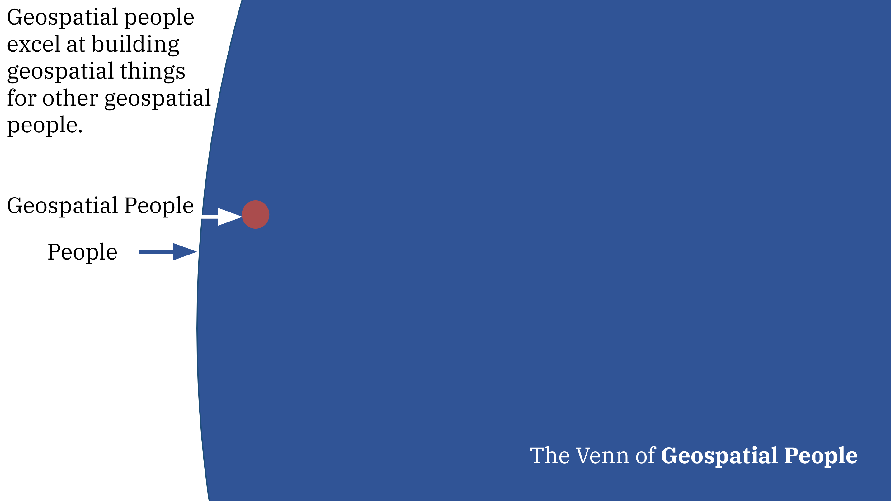
Geospatial people are great at building geospatial products for other geospatial people. That red dot of geospatial people is small in comparison to everybody else, so if we care about the growth of the geospatial sector, then we need to reach a broader audience. But, those non-experts may not be interested in seeing a map, just for the map’s sake.
So, I say with a conflicted heart that maps are getting in the way of the growth of the geospatial sector. Now, the cloud offers an opportunity to undertake enormous amounts of geographic activity independently from a mapping interface. The cloud-centric workflow of “capture data, run analysis, store data, serve data” may not need a map, or the map may not provide a user with value.
The key insight here is that because of the map-centric sales strategy of what amounts to the GIS monopoly, an overtly geographic market remains unconsidered by the traditional geospatial or GIS community. This is an opportunity for open-minded, cloud-centric geospatial companies.
But, consumer maps are also missing
Another place that Esri has largely ignored is “consumer web mapping.” For whatever reason, Esri chose not to compete with Google and Apple Maps. Interestingly, Apple has never pushed their Maps API much beyond the native mobile SDK. This is not strictly true, but in a practical sense, may as well be. So, regarding consumer web mapping, the obvious leader was Google Maps. There have always been open options but those have always taken management. Commercial enterprises looking for a plug-and-play solution would default to Google. So, the rise of Mapbox was met with celebration. Competition is good for the consumer. Though beset with complications around growth, Mapbox consistently delivered cutting-edge mapping technology, raising the community’s expectation of the maps of the future.
In recent years, Mapbox has demonstrably focused on automotive, a tremendous market. But doing that has been at the cost of the humble web map. I wonder if that focus is linked to Mapbox's retreat from the geospatial community. There was a moment three years ago, maybe more (COVID still confuses my timeline), when Google hiked their prices. That was the moment when Mapbox could have captured the market. However, that was also the moment when the automotive opportunity opened. The downside of a massive investment ticket (Softbank, amongst others, has over $600m in Mapbox) is a need to create massive revenue opportunities. Automotive is just that massive opportunity. But, as fast as some cars can go, revenue in automotive is slow. This can be seen in Mapbox’s recent hiring patterns; most technology companies had a tough year 2022/23, and Mapbox was not immune.
My point here is not to slam Mapbox in any way (see my first paragraph.) In fact, my observation is that as one of the two consumer geospatial market leaders, Mapbox is in an uncommon position to grow because numerous companies have concerns over Google’s perceived use of private data, and a price advantage. But Mapbox has become increasingly absent from the mapping community. As a sales organization, Mapbox has become great at whale hunting; automotive is a great example of that, but I wonder if the lack of discourse in the consumer mapping market has harmed its operational credibility. (Selfishly, I would also gently suggest that partners could help a lot here.) Has, Mapbox has been absent long enough that other competitors, Maptiler and Felt, for instance, have emerged to fill a perceived void?
Opportunities for consumer maps are being missed, and where maps make sense, Mapbox’s maps have been exquisite. Without a doubt, Mapbox could choose to re-engage and in 2024, I hope they do.
You might reasonably ask how this lines up with the geospatial product trap, where I basically say, “Don’t do too many things” and “Love the problem, not the technology.” My response is that Mapbox was supposed to be doing the consumer mapping business, but their exit from the mapping community has impacted their execution. Additionally, I would argue that automotive is a consumer mapping activity. While, in practical terms, these might be different products with different engineering needs, the consumer benefit of a common mapping platform is enormous.
My key insight here is that while Mapbox is waiting for the automotive revenue to kick-in, re-engaging with the mapping community would bolster its consumer mapping business which is at risk of being disrupted by new, agile entrants.
Also, as a selfish practitioner, I’d love to see Mapbox back in the discussion; competition is good for the consumer.
Hopefully, you found this commentary useful; feel free to disagree. We all learn from robust discourse. If you like it, subscribe:
Is CARTO not a thing here? Just wondering?
Also, I think with the rise of social media, few people want maps. Consider that in the new consumer landscape, facts and analysis are marginalized as maybe "nice to have", but rarely essential to the mission. Shared reasoning is 20th Century thinking, so if it doesn't tell *me* how to get to *my* next appointment, what meaning can it possibly have for me? Maps, anymore, are things that managers requisition by fiat as an affirmation of power and influence. And that too is largely a singular and personal artifice.
The former president solidly underlined the role of cartography in our society with his Sharpie pen meteorological wizardry.
IMHO, the idea that "..opportunities for consumer maps are being missed..." could be abstracted (and extended) to data presented as visual information too....charts, graphs, timelines, and more.
When we get most of our "information" from Tik-tok and AI, who needs a map? And why? And to be fair, did maps ever serve any _real_ decision process in the Anytown, U.S.A. "planning" department, where decisions are made long before the maps are created?