
The back forty
In Canada, we have an unfenced backyard and need to combine AI with satellites to solve a series of key geographic, political, sovereignty, and climate-related problems.

You would be surprised how many satellite companies have a product or project called Skynet. At Sparkgeo, we don’t, but it seems like a darkly humorous self-fulfilling prophecy to me*. However, killer robots aside, we need to combine AI with satellites in Canada to solve a series of key geographic, political, sovereignty, and climate-related problems. We have an unfenced backyard, and we need to start paying attention to our back forty.
Arrive-Can’t
If you’ve followed the Canadian news in the last few years, you will likely have heard about the ArriveCan app procurement debacle. In essence, the Canadian Federal Government paid a contracting organization an astronomical amount of money to build a travel management app during the COVID pandemic. It’s hard to imagine how a company of 5 could spend $54m in 6 months, but that’s what happened. I expect a few late nights burning the midnight caviar were involved.
This piqued my interest because my team has always had a hard time winning Canadian federal government contracts. We have won a couple, but we are not well-designed for them. Generally, the boilerplate in these Requests For Proposals (RFPs) asks for the resume of the actual developers on any project. As a small team of experts, we must keep our team busy, so it’s hard to guarantee that a particular team member will be available for a competitive bid we may or may not win. We’ve always felt that if we won the project but had to change the project team immediately, our customers would think of it as a bait-and-switch. Effectively a corporate lie. So we’ve avoided these projects; much bigger companies or much smaller companies are better designed for these.
Those, and contracting companies.
In fact, contracting companies are the winners in serving the Canadian federal government. This means that most of the Canadian government technology sector serving Ottawa could be described as techno-gig workers.
In many ways, contracting is fine; it’s a low commitment for all. Contractors take on what they want and can write off their expenses as a small business. The companies have minimal fixed staff on payroll while commanding an army of resumes to attach to RFPs.
But this arrangement has resulted in a dearth of major Canadian primes because, in techno-gig land, no one retains any meaningful IP. Without that IP, the contracting companies never do anything other than rent resumes to take on roles. One could argue that this simple accident of boilerplate has resulted in a structure that directly impacts Canadian productivity. Government spending is one of the major levers of fiscal policy. If that lever never creates IP, then it has no long-tail impact, and Canadian productivity is left in neutral.
I have always felt that investing in staff development is a more respectful employee-employer relationship, allowing my team at Sparkgeo to build both human and intellectual capital.
So, in Canada, we have a government procurement problem. That’s no real surprise. But for the sake of this discussion, it means we have few major defence primes. In this industry article highlighting the Canadian defence industry punching above it’s weight, all the six listed top companies are foreign. MDA is a notable exception to this pattern.
As usual, there are two perfect times to solve this problem:
1) Twenty years ago.
2) Now.
Luckily, the brand new Defence Investment Agency and the Canada Defence Procurement Readiness Program were both announced this week. Notably, these focus on defence procurement, not the Canadian Government. Hopefully, with some success, patterns will echo throughout the institution.
Mercator’s conceit
In Canada, we generally assume that our only border of concern is that with the US to the South or West (yeah, Alaska, remember?) Mercator inadvertently taught us** to think East and West. But in many ways, we also share a border with Russia, not to our far West (so far it’s almost East), but to our North. The Canadian Northern border is absolutely enormous, and it’s largely empty. There are some critical Northern First Nations and Inuit communities, but the vastness and ruggedness of this area cannot be understated. It’s also ripping cold, or at least it was.

Because of the nature of this area, one could say that our backyard is somewhat unfenced. For the last fifty years, that was largely fine. We’ve had the Dew Line in case things got really bad, but we are still here, so the gambit of mutually assured destruction seems to have paid off. But now, our political and environmental landscapes have changed. We have a belligerent Russia, we have an opening Northwest Passage, and we have a resource-rich North defrosting. Our backyard has become much more attractive.
Side Note: The Panama Canal is getting shallower as less fresh water is available from the surrounding forested mountains and lakes to keep the canal full. Less precipitation in the surrounding rainforests is having a drastic effect. This will ultimately be an economic disaster for Panama. As that route becomes less viable, the Northwest Passage will be enormously attractive as the quickest route from Europe to Asia.
While Canadian sovereignty has been of deep concern recently, border management is not the only concern in the North. A new climate situation is slowly emerging from the melting Northern permafrost. The methane bomb, which has been forecasted, may or may not cause atmospheric havoc, depending on the area's greening. The fact is, neither scientists nor politicians know what will happen with such an enormous landscape change. What we do know is that we cannot monitor this vast, rugged area using human resources alone.
To compound the above issues, the Canadian North is also a literal gold mine for resources, which could provide well-paid jobs and a secure, independent economic future for Canada. Resources have always been a question of where. A very geographic activity balancing the costs of extraction and logistics against the price of a commodity. That said, the ethical extraction of resources is a hugely contentious issue, yet a pathway to a secure future for our country. Canada is one of the few nations that can genuinely consider the ethical extraction of resources within the context of indigenous communities, environmental management, and broader macro-economic pressures. Indeed, the wealth of a nation is more often than not related directly to the availability of natural resources. This kind of inventory of resources should be considered holistically because, while the Canadian North is not an easy place to reach or operate in, it is possible, and there is a wealth of opportunity.

Finding a needle in a haystack of needles
We have thousands of sensors in various orbits around our planet—far more than ever before. The sheer sensory capability we have access to today, even commercially, is stunning. Petabytes of imagery tumble out of Low Earth Orbit every day. We also have this notion of infinite compute. Obviously, that’s hyperbolic, but in practical terms, we have more storage and compute capability available than any of us is willing to pay for.
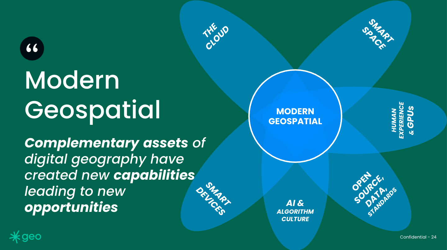
In fact, beyond Smart Space and The Cloud, we have at least six critical complementary assets that we can put to work. These assets can be combined in various patterns to build modern geospatial applications.
In fact, given that far more pixels are flowing out of the sky than any organization has the available eyes to examine, we need to leverage as much AI and compute capability as possible to understand our dynamic Earth. If we want to find any needles in this growing haystack of needles, we need to put the machines to work.
Knotty problem
So, we have several threads which we can consider in parallel.
We have a vast, rugged, remote area which is of increasing value.
That increasingly valuable asset is subject to an increasingly inhospitable political environment.
We have a procurement system which has been identified as problematic, thus creating political interest in demonstrating an alternative (sunnier?) way.
Critically, we have a technology environment that can be used to tie these threads together.
Not discussed above, but relevant:
Canada has been under increasing pressure to meet NATO commitments, which is hard to do without those major Canadian defence primes to buy things from.
The Canadian Defence budget has just been bumped up.
There seems to be a unique opportunity to think about AI to better understand our enormous and dynamic land. In fact a combination of Earth observation and AI is the only way to do this.

But what does a venture like this need to look like? Is this venture investable? What kind of organization could build or operate this system? Should it be a company, or built by Canadian Government staff developers?
To define these options, we should consider the mechanics of an operation like this and what organizations would be willing to pay for some kind of Northern monitoring capability. Clearly, the Canadian Government would have an interest (that could be a combination of Canadian Border Services, the Coast Guard, the Territories, and possibly the Department of National Defence). Additionally, any shipping or shipping-related organizations would have an interest. Insurance and resource companies will also be motivated to understand ice presence or absence.
But critically, each of these organizations will demand a slightly different products, sculpted from a common monitoring service. These different products could be actuary reports, alert emails, anomaly maps, ice maps, and routing information wrapped up into PDF documents, emails, web maps and Application Programming Interface (API) endpoints. Each product demands a different complexity, time horizon, market positioning, sales structure, cost, and price.
The idea of a series of products emerging from a single landscape engine makes me immediately consider a geospatial foundation model as the base technology to feed a Northern monitoring capability. Powered by modern geospatial technology, one single monitoring capability, a Northern Eye if you like, could be leveraged to address a series of common problems within a particular policy, climate and political environment. This deep horizontal is a great example of how both the Geospatial and AI communities mirror and indeed reflect each other.
* I still say thank you to Siri
** euro-centric reductionists, see Transitions