
Prompt disruption, geoAI took my job.
It’s all hot air until AI takes your job. In the geospatial community of practice, AI tools are making an increasingly big impact. We can choose to flip the table, or take the win.

Three weeks ago I was introduced to Lovable by Sparkgeo’s UK Lead, Dan Ormsby. The next week I messed around with it, and was deeply impressed. Last week my team published a post on it. What’s the fuss about? Well, on one hand it’s “just another prompt based code generation app” - it’s just vibe coding. Though it can provide good output, that output is still a bit rough around the edges. The code quality is reasonable, but the main complaints we had were around executing closely to user stories, thus meeting expectations. On the other hand, the products we managed to create with Lovable are exactly the kind of thing that Sparkgeo was once paid to create.
Is this a case of AI taking our jobs? Yeah it is, and I’m all for it

This week, I was lucky enough to be in Calgary for a small meeting of geospatial minds. Because N51 has been postponed due to “complicated international circumstances,” a small number decided to still meet up, as a consolation prize, so to speak. This has resulted in a short white paper which is still being edited and will be published soon. While I don’t want to steal our “geo-festo’s” thunder, three components of that discussion were:
The role of AI in the future of geospatial activities,
The notion of the horseless carriage as it pertains to product development, and
What an AI-first GIS or geospatial platform might look like.
Firstly, I am being careful to avoid the term “geospatial industry,” because I don’t think that exists, anymore. Perhaps it once did, but now, I see a community of practice. A community of individuals from a variety of backgrounds that apply the key characteristic or attribute of spatial thinking to business, human, or organizational problems. Forgive me, if I sometimes lapse and use the phrase geospatial industry, that’s usually out of laziness, or a need to help describe a concept to an insider. Probably laziness, though.
So, when we think about the geospatial community of practice, the suite of tools in use are wide and interesting. Many of those tools are introducing an AI chat-bot of some sort. We should also highlight that many of us have been using various AI practices in geospatial activities for decades. But, that does not diminish the huge and, thus far somewhat nascent, power that language and now geospatial based models can provide.
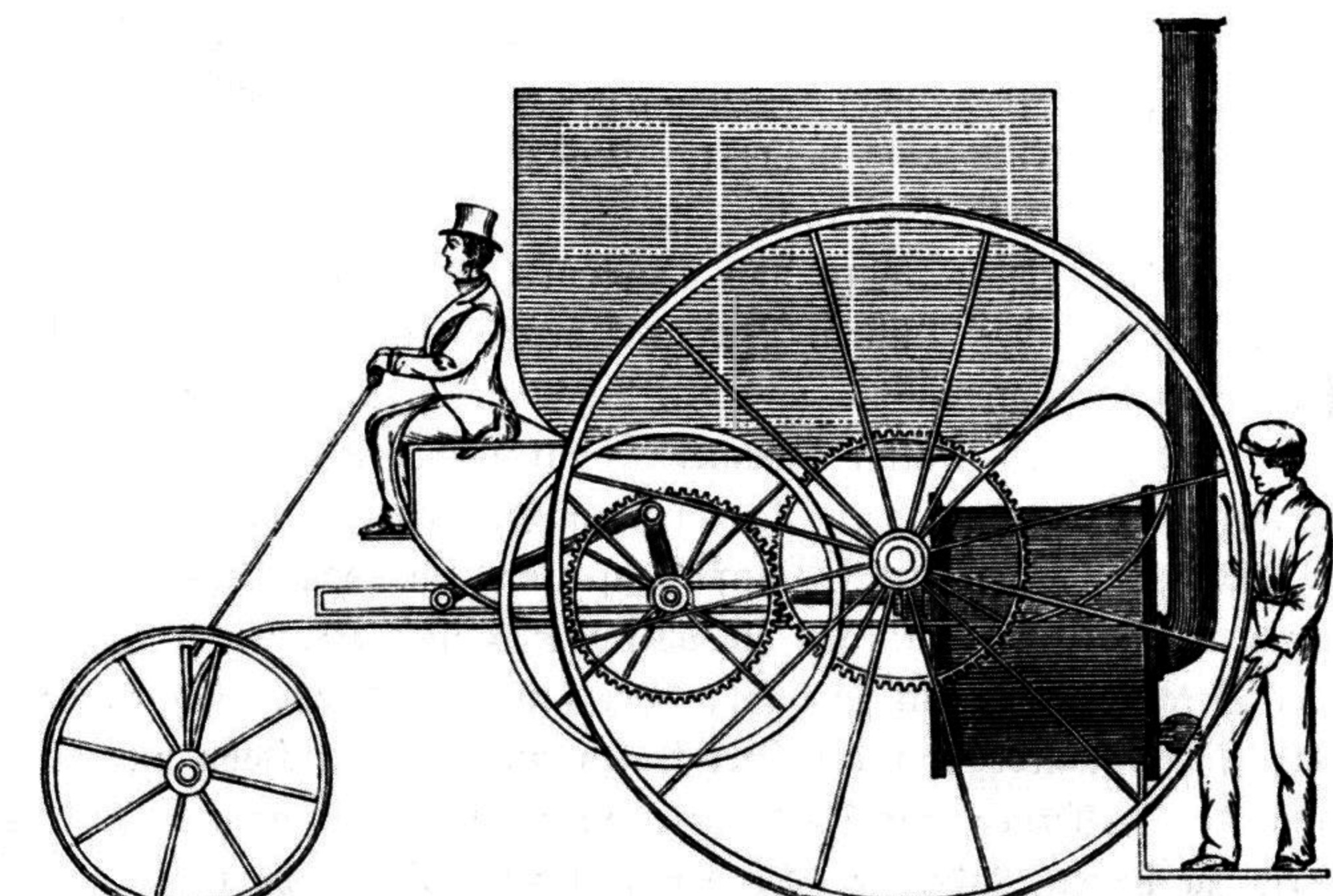
But, the addition of a geo-buddy, or a carto-copilot is exactly the problem of the horseless carriage. If a language bot is just added to a pre-existing workflow, then I would argue that AI is not being sensibly used. The horseless carriages as described here, refer to the design of the first cars. They initially looked like “horseless carriages,” meaning that instead of a new vehicle being built around the combustion engine, the combustion engine was just added to the vehicle that was already best understood by the market - the horse drawn carriage. If AI is the new geospatial compute engine, then I am curious to see the new breed of AI-first geospatial tools will look like, probably not like the geospatial platforms of today (or, yesterday, I guess.)
Would an AI-first geospatial platform ever have to think about reprojections, or would it just understand the difference between flat surface and ellipsoids? Like my phone crossing timezones, would it just know? A better question, why wouldn’t it just know? If an AI-first geospatial platform “just knows” where data is, would it ever have to worry about ETL (Extract, Transform, Load)? By that, I mean, couldn’t it just look at a data set and see what format it is then ingest it to some known common storage unit? If we can assume relatively open standards, couldn’t an AI-first geospatial platform just collide datasets together and know if/when/why a union is better than an intersection for disparate data? Indeed, could those traditional analysis techniques just happen in memory per user request? Will layer_UTM13_tmp1_final_final1.shp ever be necessary again?
Quick aside: there are already some able, modern and AI-powered geospatial tools. I would point the reader at Felt, Atlas, Ellipsis Drive, which have all come up in conversations recently, and are worth a look.
If an AI-first geospatial platform could reproject and run ETL routines, then what impact does that have on the geospatial community of practice? Specifically, what will the GIS (Geographic Information System) technician do? Experienced geospatial and GIS people respond to me that data will always need to be cleaned on some level, but will it? Then they respond that LLMs (Large Language Models) hallucinate, but humans make mistakes too, sometimes on purpose*. I can still see the need for some bespoke analysis, but we ask language models to do more and more complex tasks, so why couldn’t ChatGPT find my closest Starbucks, count cars in a parking lot, or track a snow plough? In fact, I bet with a combination of Lovable, and ChatGPT I could build that app today. But why, except to create an amusing collage of geospatial’s biggest cliches via a text prompt?
The point here is not to flip the table and say we’re done. We are most assuredly not. Firstly, we still need to build all these AI-first tools, for the next decade we’ll all be deeply involved in that activity. But more broadly, it’s to say we should look further out in time and zoom further out in approach. For our community, the concept of spatial thinking has always been the central value proposition. That has not, and will not, change. Mr Marshall is right, there is tremendous Power in Geography and Mr Dangermond’s Science of Where is also a telling message. That said, I do wonder if our community should be less focused on the how of geospatial and more on the why of geospatial.
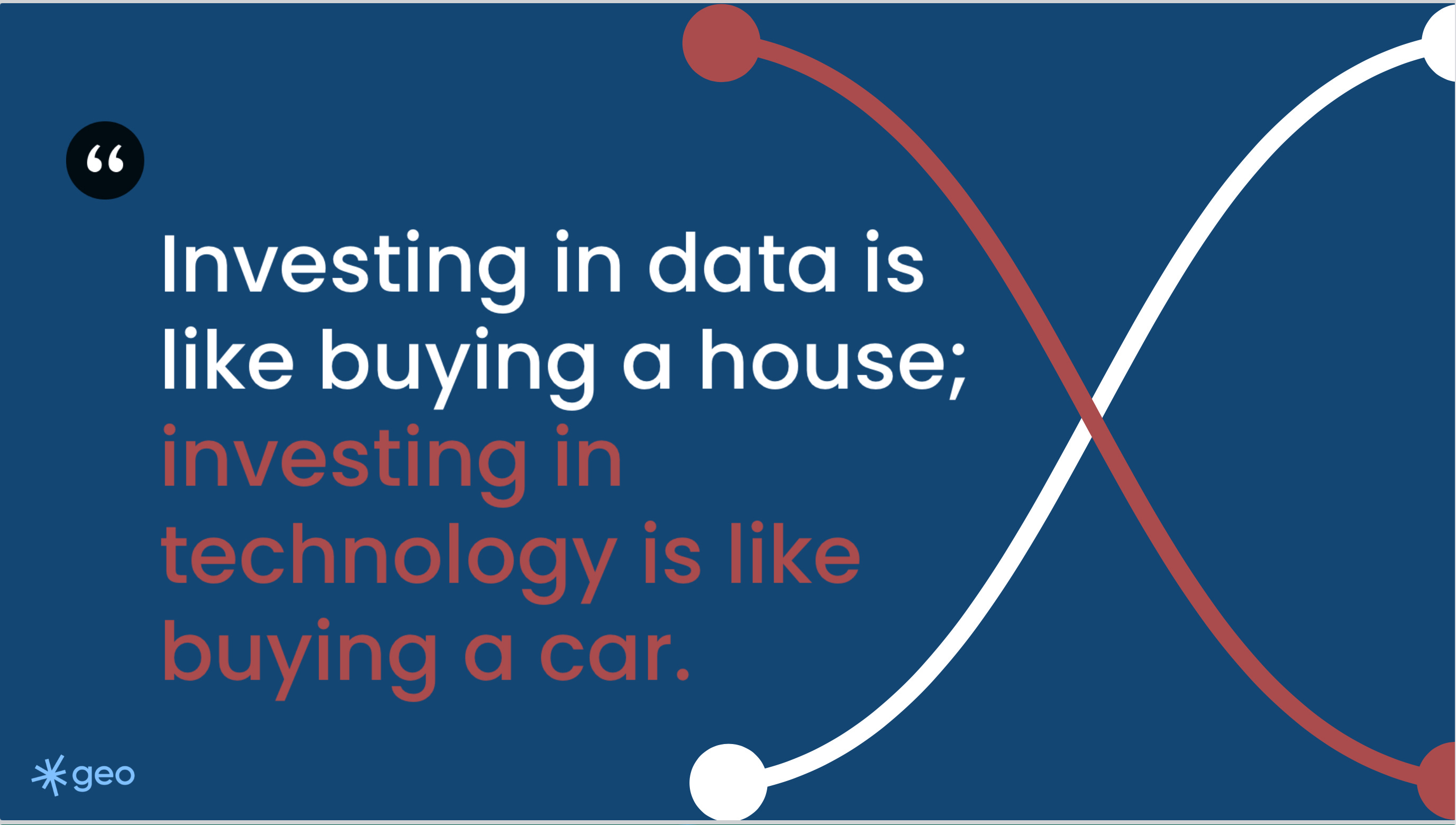
I like to say that “Investing in data is like buying a house while investing in technology is like buying a car.” This is as true today with the AI-economy as it ever was with the web-economy. Data will always be critical; it has a cost and should be cared for. Technology, however, will (and should) evolve through innovation. You must invest in both, but know where your money is going.
So, yes AI might take our jobs. But it probably won’t take the core benefit of spatial thinking, and in that we can celebrate and thrive.
*I was once working for a forest inventory company in Northern British Columbia. One of the human photo interpreters once told me he would add in “exotic species” to his species classification work, because they were allowed to add up to 5% exotic, and he was bored. So if you look at BC’s Vegetation Resource Inventory and see Monkey Puzzles trees or Bamboo, now you know.
Does AI get bored?